General Information
The Lake Martin 100
Runner Information: The following general notes are to help runners prepare for the Lake Martin 100. However, nothing can prepare you as well as getting out on the course and becoming familiar with the trails and the terrain. Every part of the course is easily accessible from the trailheads making it an easy course to scout in sections. Arrive a day or two early and do a little hiking along the trials. This manual as well as the course description, images of the course and profiles, available on the website will provide additional information.
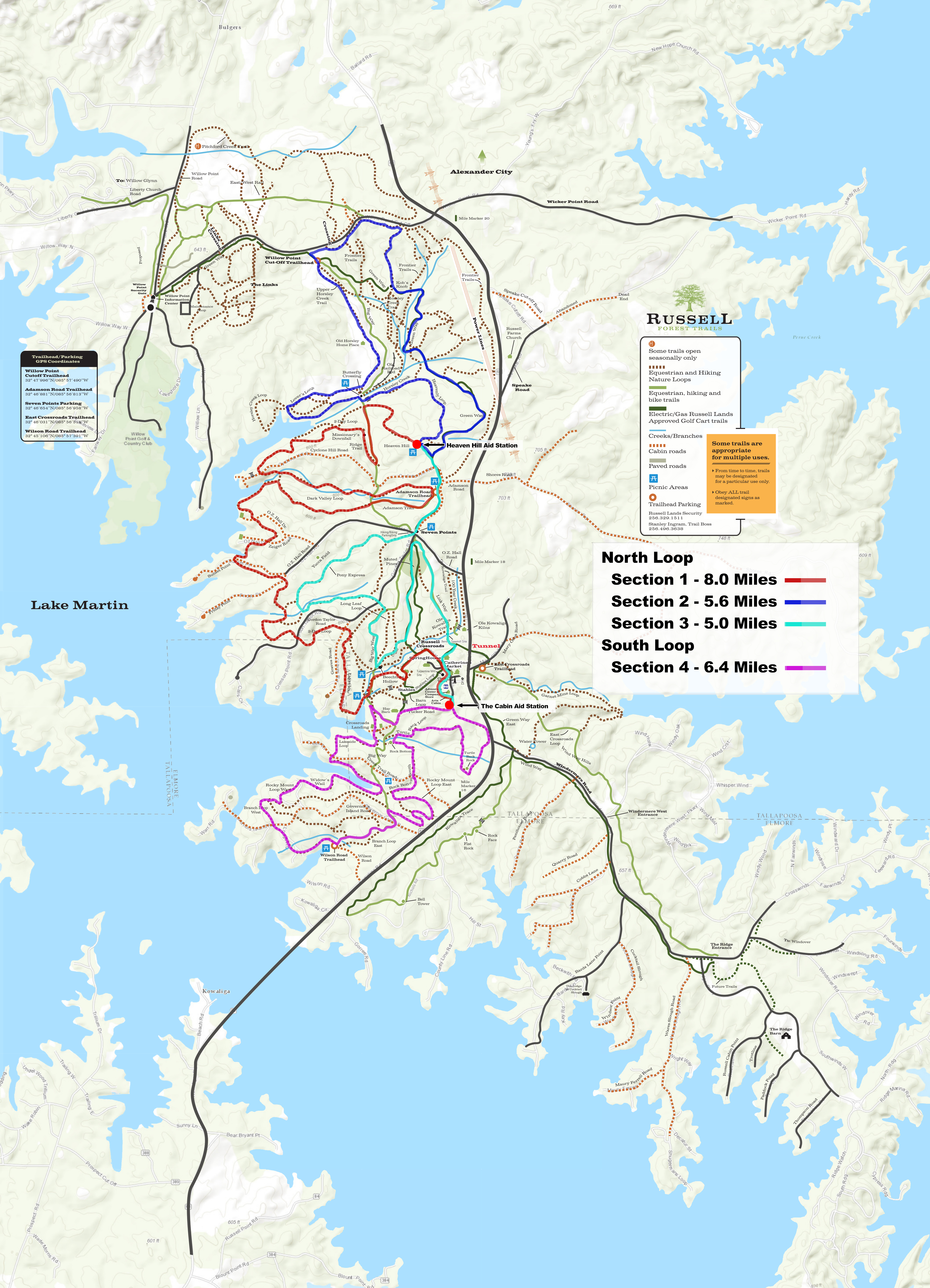
The Course: The Lake Martin 100, 50 & 27 are “Closed Courses.” This means, you MUST follow the specified race course. Route finding and cutting corners is no allowed and may result in disqualification. The course is easy to follow and flagging will be sufficient to keep runners on the course if you pay attention. The course is laid out like three “Os” side by side a “OOO.” Aid stations are located where the “Os” almost touch. See the diagram of the course, Section 4.1.
The trails in the Russell Forest Trail System: The trails in general are in great conditions. Every trail is easy to run “runnable” for everyone including first time trail runners. There are a lot of roots, but the course is almost entirely in the woods. That is why it is called The Russell Forest Trail System. There is nothing trail runners that live in this part of the country would call technical, anywhere on the course. The course is hilly with beautiful rolling hills from one end to the other but most of the hills are less than 100 feet of elevation gain. The only thing that can actually be called a climb is the trail to up Heaven Hill, the high point on the course, with about 200 feet of elevation gain.
The soil is very sandy and drains rapidly. As long as it doesn’t rain hard during or just prior to the race, most runners will be able to keep their feet dry the entire race. There are a few boggy areas, but all are very short and can be totally avoided. There are many creek crossings around the course and some trails follow creeks and cross back and forth. All can be crossed without stepping in water if you are willing to take the time to pick your way across. 2014 was the exception. Late winter was very wet, so the trails were waterlogged before race weekend. Race morning as much as 3.5 inches of rain fell in the two hours prior to the start and during the first hours of the race. Need I say more!
The Weather: This is Central Alabama. Late March can be anything from very hot and humid with temperatures approaching 90 or it can be very cold and wet with temperatures in the 30”s. Be prepared for anything. The average temperature range for March 20th is 46 deg. to 72 deg. The average chance of rain sometime during a 24 hour period in March is 25%. There is an 18% chance of Thunderstorms in that same 24 hour period. That means there is better than a 75% chance the sky will be clear.
Route Finding: The Lake Martin 100 is not an Orienteering Adventure. It is a race, and our goal is for you to be able to concentrate on racing and not worry about getting off course. That said, runners still must stay focused and pay attention to course marking. The entire course is marked with 4 X 5 Blue Flags. Virtually all of the flags will have DOT reflective tape attached to the flag to make it more visible for 200 to 00 yards away at night. In some areas these reflective flags will be line-of-sight. We also use small signs, with arrows and DOT reflective tap at critical points on the course where runners could easily make a wrong turn. If you pay attention you will not miss a turn.
There is always the possibility that something will happen to a few flags or signs. A bike or carriage might knock some down or a child might pull a few up. It’s a good idea to have a basic knowledge of the course and carry a map with you during the race, especially the first couple of laps.
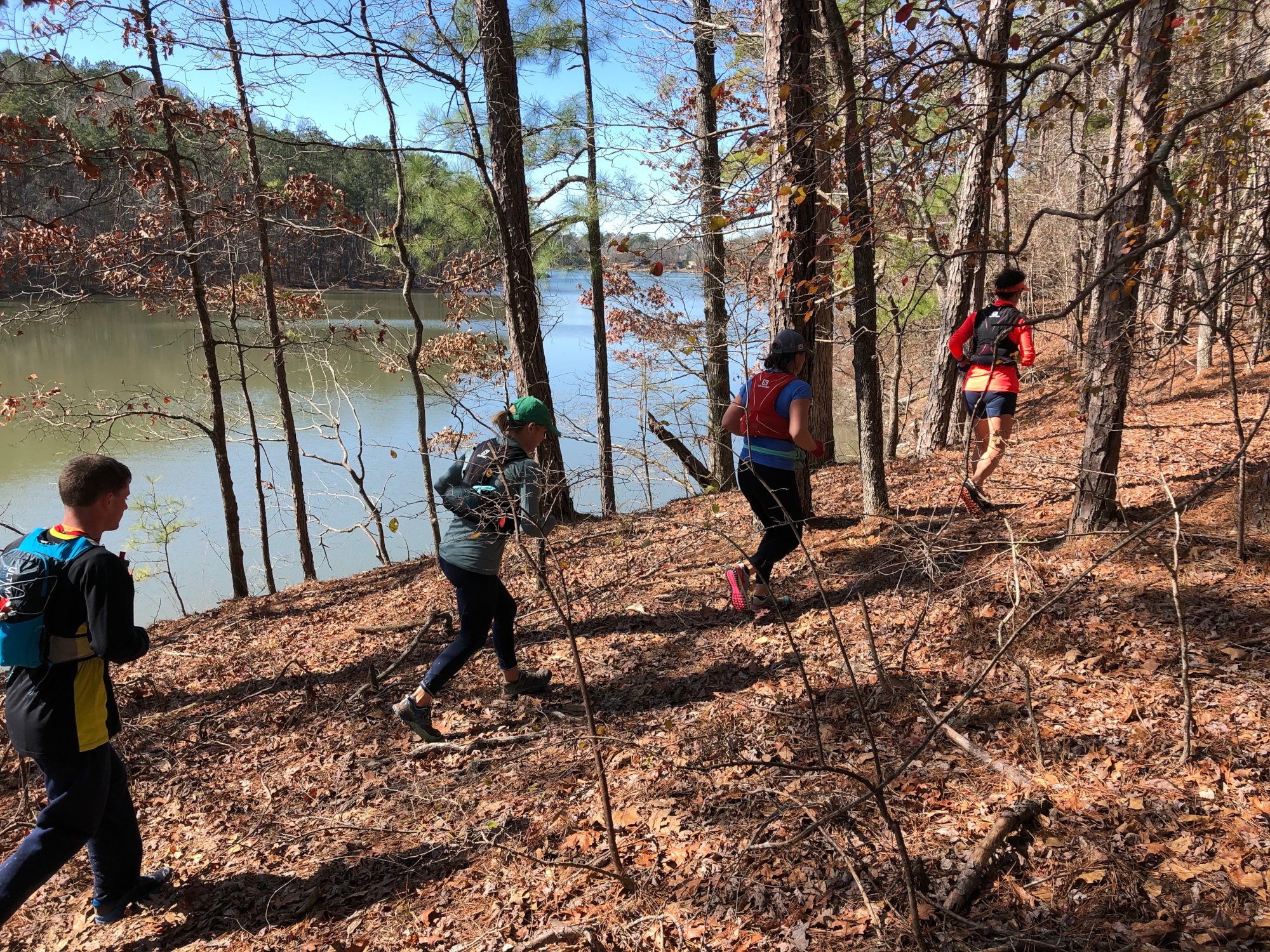
Below are Examples of Southeastern Trail Runs Trail Marking


The image on the Left is from Lake Martin The image on the Right is from Hotter ‘N Hell
Training: The Lake Martin 100 course is a relatively easy and safe course compared to many 100 mile races. There are no 13,000 foot, snow covered passes to cross. There are no traverses through cliff bands where a slip could send you 500 feet down a sheer rock face. There are not even any technical sections where you must negotiate tricky rock covered climbs or descents. You will never be more than about 3 miles from an aid station. This is why there are not qualification requirements for this race. What the Lake Martin 100 does have, is 100 miles to cover on foot from the start to the finish. Most finishers will need 25 to 32 hours to complete the race. This is an unimaginable feat for the vast majority of runners, let alone the general population. The training is the one component we have no control over. It is totally your responsibility to be physically and mentally prepared for the endeavor you are about to embark upon. If you have not run a 100 before I would suggest you do a little research. Hal Koerner has a great book, “Field Guide to Ultrarunning.” He knows what he is talking about. “I Run Far” has lots of good stuff on running ultras and 100s .I also have a blog “Run Your First Ultra” that you might find some worthwhile information in. Good Luck.
Dropping from the race: Unfortunately, it is as much a part of running 100 mile races as are blisters. A lot of runners drop from 100 mile races. Less than half of the runners that started the 2013 Leadville 100 finish. Oddly enough, only about 31% of the starters at the 2013 Hardrock 100 failed to finish, arguably the hardest 100 on earth (that can be considered a real race.) Both races had perfect weather a rare event is the Colorado Rockies. What was the difference? To get in Hardrock you must have finished, one of 22 of the hardest 100 mile mountain races in the world within the last two years. Yes, there will be a fairly high percent of runners that drop at Lake Martin. But there will be a much higher percent that make it. Don’t even let dropping be an option in your mind. Stay focused on finishing.
If you do find it necessary to drop, if you must be pulled from the race, or if you miss a cutoff at The Lake Martin 100, you will not be far from your crew or your car. There are 3 trailheads less than 5 miles from the start and there is the start/finish itself. You are probably never more than two miles from one of the trailhead or aid stations anywhere on the course. If you must stop you can call your crew and they will be able to pick you up at any of the trailheads. Just remember, if you drop, you MUST return to one of the aid stations and officially drop from the race by notifying the aid station captain or a race official. Please do not just leave. If we cannot account for a runner, we will organize a search and rescue mission with local first responders. They will not be happy if they find you sleeping in your hotel room several hours later.
Carry Water at all Times during the race: The first aid station is a very long 7.26 miles from the start to Heaven Hill Aid Station. It will take you considerably longer than you think to get there. 50 and 100 mile runners MUST carry water.
Cutoffs: Cutoff times will be enforced with exception. Please do not argue with a race official. The cutoffs are set so that if you do miss a cutoff, it would be impossible for you to finish the race under the 32 hours. We will enforce cutoffs if it is obvious a runner cannot finish in the allowable time, with exception.
Cutoff Exclusions:
Exclusion 1 - We must close Heaven Hill Aid Station and The Cabin Aid Stations per our agreement with Russell Lands, at the Cutoff Time. You have signed a release allowing you to use the Russell Forest Trail System, so in reality, you may continue running. You must understand, if you choose this option, you are “on-your-on” so to speak. If your family or crew accepts responsibility for supporting you, (a crew member must sign a release accepting that responsibility) you may continue as long as you like with one exception*. If a runner has no crew, the runners must sign the release. There are no exceptions.
Exclusion 2 - The Aid Station Caption for RD must approve your continuing to run past cutoff. If you ate strong and it is obvious you can complete the course before dark, we will allow you to continue. If we feel you are not going to be able to make it, you must stop.
The Exception - You must be off the trails before dark Sunday. This rule is enforced by Russell Lands Security. All of the Russell Forest Trail System trails close at dark and the security people DO patrol the Trail System. The Lake Martin 100 is the single exception to this rule. LM100 Runners are allowed to run overnight on Saturday night of the race. You may NOT be on the trails after dark Sunday night.
Aid Stations MUST Close at the posted Cutoff Times - Runners that continue, are selfsupported.
Getting to the Lake Martin 100
Russell Crossroads is located in East Central Alabama near Alexander City. Russell Crossroads is 80 miles southeast of Birmingham, 140 miles southwest of Atlanta and 49 miles northeast of Montgomery. Montgomery is the closest airport but also the smallest with a limited number of flights. Birmingham Shuttlesworth Airport is larger and has more flights. Russell Crossroads is also a straight shot down Hwy 280 and is about 5 miles from the Birmingham airport. Atlanta is about as big as an airport gets and every major carries flies into Atlanta. It is also a relatively easy drive since Hartsfield-Jackson Atlanta International Airport is located on the southwest side of Atlanta, right on Interstate 85, the highway leading toward Lake Martin.
Montgomery Regional Airport is the closest, 49 miles from Russell Crossroads. This is a small airport with limited daily flights.
Link to Google Maps Driving directions from Montgomery to Russell Crossroads.
Birmingham-Shuttlesworth International Airport: Is an easy drive to Russell Crossroads. Once you get Hwy 280, 4 miles from the airport, it’s a straight shot all the way to Alexander City. (Warning – Hwy 280 is Birmingham’s worst driving nightmare!) If you arrive late in the day and end up heading south on Hwy 280 after 4:00 PM it could easily take 2 1/2 hour to get to Russell instead of the predicted 1 hour, 45 Minutes.
Link to Google Maps Driving directions from Birmingham-Shuttlesworth Airport to Russell Crossroads.
Atlanta, GA - Hartsfield-Jackson Atlanta International Airport: It’s a long drive from Atlanta but usually the traffic isn’t too bad since the airport is on the southwest side of town. The airport is 137 miles, 2 hours, 15 minutes from Russell Crossroads. It is the most likely airport to have a direct flight from wherever you live.
Link to Google Maps Driving directions from Hartsfield-Jackson Atlanta to Russell Crossroads.
Parking at Russell Crossroads
Lake Martin 100, 50 & 27 Runners and Crew must park in the areas indicated in green on the map on the left. DO NOT park in front of or beside Catherine’s Market. Do not park in areas marked in Red. Personal Aid Stations may be set up in the large green shaded area to the left in the image immediately below.
Crew Parking at Adamson Rd Trailhead & Access to Heaven Hill Aid Station
Crew must park at Adamson Rd Trailhead if they plan to provide aid at the Heaven Hill Aid Station. Do NOT drive past the iron gate and signs saying “NO CREW CARS.” Hike 470 yds. to the aid station. Follow the signs directing you to Heaven Hill. Hike down the “Green” gravel road to Heaven Hill, walking toward the oncoming runners.